I agree to and consent to receive news, updates, and other communications by way of commercial electronic messages (including email) from Tectonic metals. I understand I may withdraw consent at any time by clicking the unsubscribe link contained in all emails from Tectonic metals.
Geology
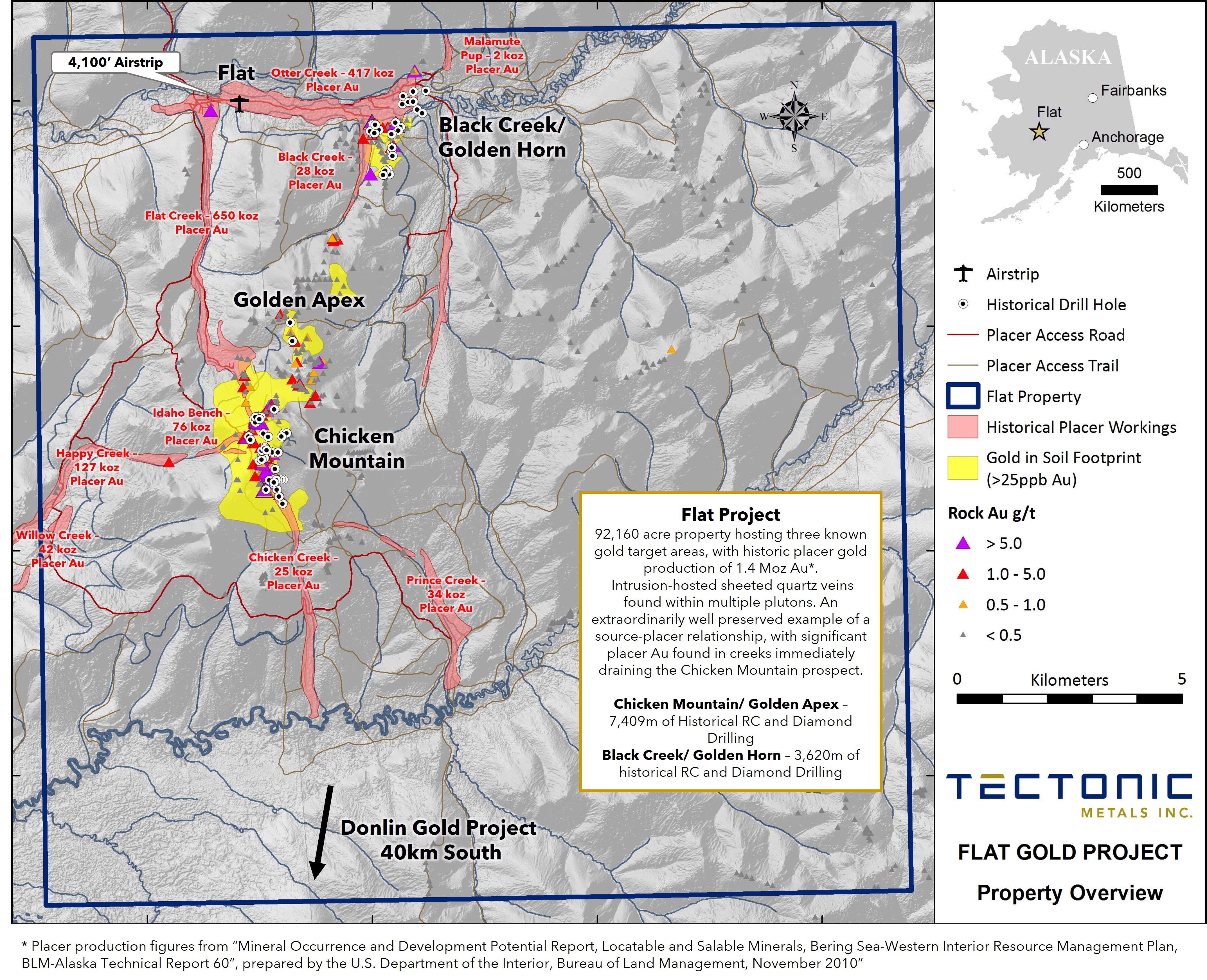
The Flat Gold Project is located in the Kuskokwim Mineral Belt and hosts bulk tonnage, intrusion-related gold mineralization similar to that found at the Fort Knox gold mine (Alaska), owned and operated by Kinross Gold Corporation.
Structurally, the Flat Project sits immediately north of the Iditarod-Nixon Fork Fault. The dominant structural feature in the region is the extensive right-lateral, strike-slip fault, which extends through the project area. Substantial vertical movement is inferred across the fault with the north side up thrown.1
North of the fault zone, partially unroofed, multiphase stocks of Chicken Mountain and Black Creek (68.3 to 73.2 Ma) intrude Kuskokwim sediments and are genetically related to accumulations of intermediate and felsic volcanics. Hornfelsing occurs within sedimentary and volcanic rocks adjacent to the intrusion margins and in areas of suspected unexposed intrusion cupolas.
For reference, south of the fault, hypabyssal bodies of rhyolitic porphyry intruding Kuskokwim sediments are predominant, with rhyolitic dike swarms hosting the Donlin Creek Deposit which contains a resource of +39 million ounces of gold 2. Age of intrusion and mineralization of the Donlin dykes ~71Ma is similar to the age of emplacement of the Chicken Mountain complex3.
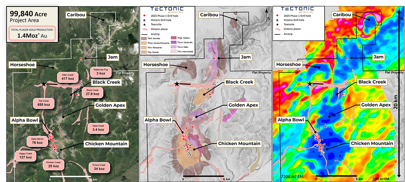
There are six district or kilometre scale intrusion-hosted gold targets (Chicken Mountain, Golden Apex, Black Creek, Horseshoe, Jam, and Caribou) on Flat’s land package, the primary target at being Chicken Mountain.
Chicken Mountain comprises an open ended +100 ppb gold-in-soil anomaly extending 3.8km x 0.6km in a north-northwest orientation over the core of the mapped intrusion. Flat is widely recognized as one of the best examples of the direct relationship between placer gold and bedrock sources, making it a valuable case study in geologic research. Gold shed directly from the intrusions has contributed 1.4 Moz of placer gold historically produced from streams draining the Flat Intrusions; Chicken Mountain is credited as the primary bedrock source.4
Three major compositional phases are present: monzodiorite and gabbro comprise the initial phases, biotite monzonite forms the transitional phase and leucocratic quartz monzonite forms the central phase.
Bedrock gold mineralization has been recognized in at least two settings:
Bulk-tonnage, intrusion-related, hosted in fractured and veined phases of the Chicken Mountain stock, including Alpha Bowl, interpreted as its northern, coarser-grained biotite-pyroxene monzonite extension. The adjacent Black Creek stock represents a separate intrusion body that also hosts intrusion-related mineralization.
Contact-related vein and disseminated bulk-tonnage mineralization hosted within sedimentary and volcanic rocks. This is best developed at the Golden Apex target between the Chicken Mountain and Black Creek stocks and the Golden Hornfels zone along the eastern contact of Black Creek. It is also observed farther north at the Jam target.
References
- 2002 Annual Report, Flat Property, Alaska. Prepared for Doyon Limited on behalf of Ventures Resource Corporation, February 2003.
- Donlin 2021 NI 43-101 Technical Report. Tonnage: 541,337kt at 2.24g/t Au. Measured & Indicated: 39,007koz Au. Assuming an average recovery of 89.5% and average 5% grade of 1.07, the marginal gold cut-off grade is 0.47 g/t. Gold price of $1,200/oz is assumed
- MacNeil, K. D. (2009). The timing and structural evolution of the Donlin Creek gold deposit, southwest Alaska (T). University of British Columbia. Retrieved from https://open.library.ubc.ca/collections/ubctheses/24/items/1.0052896
- Placer production figures from “Mineral Occurrence and Development Potential Report, Locatable and Salable Minerals, Bering Sea-Western Interior Resource Management Plan, BLM-Alaska Technical Report 60”, prepared by the U.S. Department of the Interior, Bureau of Land Management, November 2010
Maps
View +